DAYS
Garmisch-
Partenkirchen
Trail
The highlight for all speed fans on friday afternoon
Sold out
28,5 km
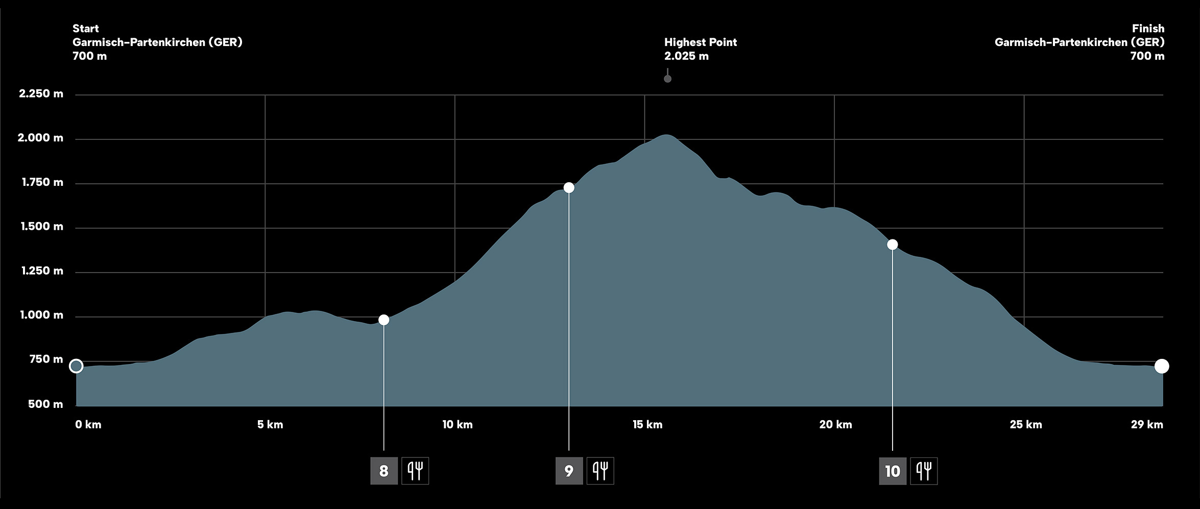
↔ Distance
1.440 m
↑ Ascent
1.440 m
↓ Descent
June 13, 10:00
Garmisch-Partenkirchen
Start
7 h
Time limit

GARMISCH - PARTENKIRCHEN
START
:
:
3D Map
Mit Links-Klick + Halten kannst Du die Karte bewegen
Mit Rechts-Klick + Halten kannst Du die Karten drehen
Mit deinem Mausrad kannst Du hinein/heraus zoomen
Use left-click + hold to move the map
Use right-click + hold to rotate the map
Use mousewheel to zoom in/zoom out
March table
| # | Waypoints | Altitude | Ascent (m) | Descent (m) | Distance (km) | To finish (km) | Time fast | Time slow | Time limit |
|---|---|---|---|---|---|---|---|---|---|
| 1 | Start: Garmisch-Partenkirchen | 700 | 0 | 0 | 0,00 | 29,00 | 10:00 | 10:00 | – |
| 2 | Partnachalm | 990 | 290 | 0 | 5,50 | 23,50 | 10:26 | 10:56 | – |
| 3 | 8 Laubhütte | 980 | 400 | 103 | 8,00 | 21,00 | 10:34 | 11:24 | 11:30 |
| 4 | 9 Hochalm | 1.700 | 1.110 | 103 | 12,50 | 16,50 | 11:07 | 13:02 | 13:10 |
| 5 | Osterfelder | 2.025 | 1.430 | 103 | 15,00 | 14,00 | 11:28 | 13:50 | – |
| 6 | 10 Trögllift | 1.358 | 1.465 | 880 | 21,00 | 8,00 | 11:50 | 15:08 | 15:30 |
| 7 | Hausberg Talstation | 730 | 1.465 | 1.450 | 27,00 | 2,00 | 12:05 | 16:15 | – |
| 8 | Finish: Garmisch-Partenkirchen | 700 | 1.470 | 1.470 | 29,00 | 0,00 | 12:12 | 16:35 | 17:00 |
The actual kilometers and altitudes vary depending on the measurement method between +/- 5%.
The carriage of mandatory equipment and the determination of cut-off times are mandatory for safety reasons.
Short-term, weather-related route changes are possible at any time.
Mandatory Equipment
| ▢ | Closed trail running shoes with a tread that is suitable for running in alpine terrain |
| ▢ | Running back pack |
| ▢ | Waterproof jacket |
| ▢ | Warm extra clothing (long sleeved shirt or shirt with arm warmers and running pants or leg warmers); basic rule: it is not allowed to see any skin! |
| ▢ | Gloves and a warm hat |
| ▢ | Labeling of a competitor’s food / beverage supplies by the individual’s start number |
| ▢ | Drinking vessel to get drinks at the food stations |
| ▢ | Water tank containing at least 1 liter |
| ▢ | Emergency kit (1x sterile dressing 4”x4”, 2x field dressing, 2x sterile gloves, 1x triangular bandage, 4x band-aids 1x emergency whistle, blister pads, rescue blanket) |
| ▢ | GPX watch with complete course data saved to memory, alternatively: the printed course map(s) and elevation profile. Map material will be made available online by the organiser for printing |
| ▢ | Mobile phone with MEDICAL CREW number saved in its address book to be able to make emergency calls (it must be made sure that the phone can make calls from within Austria as well) |
| Checklist-Download |
The race organizers will perform random checks prior to the race start and at various check points on whether the aforementioned mandatory equipment/clothing is indeed being carried along. If mandatory equipment were to be missing, the participant in question will get time penalty or will be disqualified from the race.